
Latest Version
Version
3.3.0
3.3.0
Update
October 19, 2024
October 19, 2024
Developer
California Department of Transportation
California Department of Transportation
Categories
Maps & Navigation
Maps & Navigation
Platforms
Android
Android
Downloads
0
0
License
Free
Free
Package Name
gov.caltrans.quickmap
gov.caltrans.quickmap
Report
Report a Problem
Report a Problem
More About QuickMap
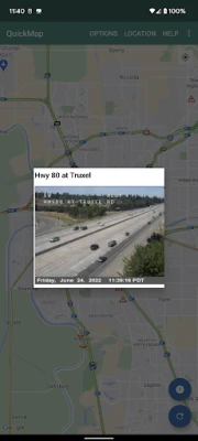
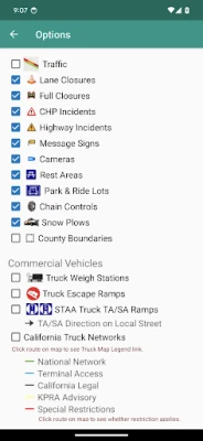
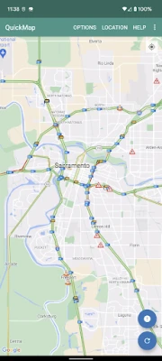
Get your California traffic information directly from the source. The Caltrans QuickMap app displays a map of your location along with real-time traffic information including:
Freeway speed
Traffic camera snapshots
Lane closures
CHP incidents
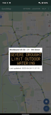
Changeable message signs
Chain controls
Snow Plows
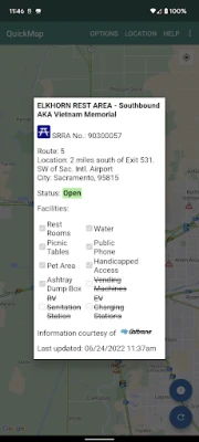
Safety Roadside Rest Areas
Border Wait Times
Park & Ride Lots
Truck Weigh Stations
Truck Escape Ramps
STAA Truck TA/SA Ramps
California Truck Networks
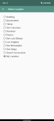
Set which of these options to display and QuickMap will remember your preferences. Zoom to a view of other parts of California with the Location button. Click on traffic camera icons to see a camera image. Click on a CHP, lane closure, changeable message sign or chain control icon to view details for that marker.
Traffic data is updated every few minutes. Load the latest data on the map using the Refresh button.
If you choose to enable Geotargeted Notifications, this app will monitor your location in the background and alert you (via a Push Notification) to State Highway System road closures occurring near you. Continued use of background location may decrease battery life.
Something not right with the data displayed on the map? Please send us an email to quickmap@dot.ca.gov rather that letting us know with a low-rated review.
Traffic camera snapshots
Lane closures
CHP incidents
Changeable message signs
Chain controls
Snow Plows
Safety Roadside Rest Areas
Border Wait Times
Park & Ride Lots
Truck Weigh Stations
Truck Escape Ramps
STAA Truck TA/SA Ramps
California Truck Networks
Set which of these options to display and QuickMap will remember your preferences. Zoom to a view of other parts of California with the Location button. Click on traffic camera icons to see a camera image. Click on a CHP, lane closure, changeable message sign or chain control icon to view details for that marker.
Traffic data is updated every few minutes. Load the latest data on the map using the Refresh button.
If you choose to enable Geotargeted Notifications, this app will monitor your location in the background and alert you (via a Push Notification) to State Highway System road closures occurring near you. Continued use of background location may decrease battery life.
Something not right with the data displayed on the map? Please send us an email to quickmap@dot.ca.gov rather that letting us know with a low-rated review.
Rate the App
Add Comment & Review
User Reviews
Based on 0 reviews
No reviews added yet.
Comments will not be approved to be posted if they are SPAM, abusive, off-topic, use profanity, contain a personal attack, or promote hate of any kind.


More »

Popular Apps

Call of Duty®: Warzone™ MobileActivision Publishing, Inc.

Marvel Contest of ChampionsKabam Games, Inc.

ChatGPTOpenAI

OneStream LiveOneStream Live

Prank ToolsKyoz

Dream Family - Match 3 GamesPlayflux

Downtown Gangstas: War GameDYNAMICNEXT

CO FITShenzhen Coding IOT Technology Limited

Simply Sing: My Singing AppSimply Ltd

Shadow of Death: Offline GamesBrave HK Limited